May 28, 2014
We left Diamond Lake late after Greg had another bike ride around
the lake. Following the Umpquah River Valley we drove west back to
the coast. We hit the coast again at Bandon and drove south on
coastal Route 101 until we reached the turnoff for Cape Blanco State
Park. A six mile drive, in which we passed fields of sheep,
wildflowers, and three elk bounding into the woods, brought us to the
campground in a gorgeous forest. We came here after reading blogs
from lighthouse volunteers, wheelingit.us, and technomadia, Finding a
secluded campsite with water and electric, (first electric since San
Francisco), in mossy trees, ferns and iris, we slept well, sheltered
from the winds.

Tuesday we devoted to exploring this awesome bit of the Oregon
Coast. The sun was shining, no clouds were in the sky, there was a
slight breeze and temps in the low 60's. We hit the weather jackpot
for the damp, unpredictable Oregon coast! We spent the day exploring
the bluff with the still operating lighthouse, (closed for the day),
and stood on the second most westerly point in the continental U.S.
Then we explored the north and south beaches, and the tidal pools.
Taking a break back at the rig for lunch, we wound up climbing up and
down the steep cliffs three times in various spots in order to see
everything.
 |
| Looking northwest along Cape Blanco |
 |
| Looking south toward Port Orford from the former marine terrace about Elevation 220 |
 |
| Cape Blanco Light |
 |
| Still active fresnel lens |
 |
| Cow Parsnip Everywhere! |
 |
| Looking at the bay on the north side of Cape Blanco |
 |
Iris and ferns in our campsite
|
 |
| Hiking down to the beach just north of the lighthouse. This slope and the beach were extensively mined for gold until 1940. |
 |
| Confusing subduction zone geology with dark marine sandstones and an odd mix of metamorphic rocks. |
 |
| Gray sand beach remaining after decades of gold mining |
 |
| Metamorphic greenschist and blueschist boulders were plentiful on the beach. I never found the outcrop, maybe they were excavated during gold mining before 1940. |
.jpg) |
| Fossil-rich, shallow marine sandstone boulder from higher up the bluff. |
 |
| Huge logs were stranded where past storms left them |
 |
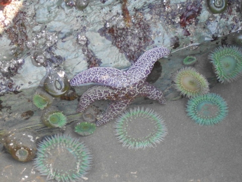
| The sea life loved the grainy gray sandstone but did not thrive on the smooth, slippery greenschist. Is the rock too smooth to hang on to or does it contain toxic metals, such as chromium? |
 |
| The south beach was more exposed and much wider with a lot of drift wood. Four-foot diameter logs were common. |
 |
| New dunes growing where the prevailing west wind pushed sand up against the cliff. |
 |
| Fresh deer prints on the beach - looking for salt or avoiding biting flies? |
 |
| The isolated rocks, marine sandstone, offered a place to hang on when the surf came in. |
 |
| Green Anemone |
 |
| Mussels and anemone |
 |
| Outcrop of dark, hard sandstone (Otter Creek formation?) that also formed the rocky islets 1/2-mile off shore. |
 |
| This sea stack was popular with nesting birds and surf zone sea life |
 |
| A long climb back up to the top of the bluff. |
It rained overnight, but by the time we got up Wednesday, the
weather had cleared up again. We posted two blogs, since we had a
surprisingly strong internet signal, but no phone. Then we left to
travel farther up the coast.


No comments:
Post a Comment
Your comments encourage me to keep posting!